

FLA Solutions
As-Built Blueprint Solutions
Acquiring as-built blueprints is a time-consuming process. FeatherLong Aerial’s feature extraction greatly reduces this process. FLA extracts any feature visible in the aerial data. From paint lines to powerlines, your project area is quickly converted into a 3D blueprint model that can be imported directly into your design software.
Colorized point cloud

Blueprint linework

DWG as seen in AutoCAD

Blueprint Output Formats:
SHP file containing geometry data, DBF attribute format file, SHX shape index file, PRJ project file, DWG drawing file
And More
Streamline as-built blueprints with FLA's aerial collection
Photogrammetry & High-Resolution Imagery
FLA offers high-resolution imagery of your area of interest for logistic planning with construction projects, provides insights into vegetation health, supplies sufficient resolution for species identification, and so much more.

_edited_edited.jpg)


Manage your project area with confidence using updated high-resolution imagery
Urban Topographic Solutions
Acquiring accurate contour maps and digital elevation models is costly and time-consuming, with results of limited resolution. FLA delivers high-resolution centimeter-accurate contours down to 0.1-meter intervals (0.5ft) in a matter of days at a fraction of the cost. FLA provides a Digital Elevation Model your engineers can confidently use for your design.
Imagery from Google Earth
FLA's Digital Elevation Model with Contour Line Overlay

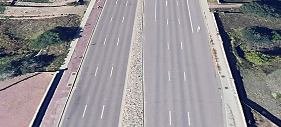
Side Profile of Roadway Showing Elevation Accuracy

FLA delivers urban topographic maps and Digital Elevation Models in a fraction of the time of standard methods with much higher resolution.
Mountainous Topographic Solutions
Accurate topographic maps in mountainous terrain are very difficult to acquire. FLA's aerial collection makes this a simple process with outstanding results. FLA delivers high-resolution topographic maps of any terrain in a matter of weeks.


No matter how steep and difficult the terrain, FLA is prepared to tackle the most extreme environments.
Encroachment Solutions
Clearing utility corridors of vegetation requires large crews and expensive equipment. FLA narrows down and prioritizes the areas that need the concentration of resources to properly mitigate the encroachments. Your team will be provided with prioritized maps showing the exact location and elevation of the vegetation requiring removal, maximizing productivity.
Classified Point cloud views with classified encroachments: Pink=severe Red=moderate


View of encroachment zones imported into Google Earth

Streamline mitigation efforts by knowing where to go and what to cut.
Tree Management Solutions
Getting an accurate inventory of your forest takes tremendous time and effort, and the results are less than accurate and highly averaged. With FLA’s digital twin, we easily count, measure, and georeference every tree in a single stand, giving you the most precise results possible for better resource management and conservation efforts.
Colorized Point Cloud (Left) Tree Locations and Statistics (Right)


Trees Classified in Point Clouds


Streamline forest management, tree inventory, and planning with FLA's Digital Forest Twin
Multispectral Solutions
Evaluating plant health over large areas has long used a sample and average approach. With FLA’s multispectral aerial imaging, you can now gain insight into large-scale vegetation health. Track plant health and stress throughout a growing season and receive data about location-specific issues (gaps in watering, fertilizer, and sunlight patterns, ect.). Bring your plant management into the 21st century with the latest in multispectral imaging.
True color reflectance imagery over ponderosa pine rows

NDVI displaying health of young ponderosa pines

What is working and what needs to be improved? Find out with FLA's Multispectral Solutions.
SLAM Solutions
FLA’s SLAM (Simultaneous Localization and Mapping) Solution is utilized indoors or in GPS-denied areas (underground). SLAM further enhances your ability to build a digital twin of your world. FLA stiches the ground-based point cloud data into your aerial point cloud to create an internal and external digital twin or a standalone internal digital model.


Import point cloud data into design software and streamline the production of your as-built 3D models!

Hydrology Solutions
FLA Hydrology Solutions deliver a hydro-flattened topographic DEM and contours where waterbodies have a single elevation and streams and rivers are flat bank-to-bank, with monotonic flow. Hydro-flattened data is delivered in accordance with the following parameters as defined in the USGS LIDAR Base Specification Guidelines.
FLA can provide high resolution topographic data for flood modeling to predict and evaluate the integrity of the flood planning for the area of interest. Simulation of water volume and velocity through infrastructure and natural water body formations provides accurate flood boundary predictions.

